If you, like me, came to Tenerife to seek challenging trails, hard rocks, curvy paths and beautiful views you won’t be disappointed. Today I present first from many run/hikes runs I’m covering during my short summer break on Tenerife.
The inspiration for this route came to me naturally when I was driving on the highway and passing Adeje. Huge mountains are growing straight behind the town, and from the moment I’ve seen them, I knew I have to go there. Later when I was browsing the walking guide, I bought for this trip I’ve found a route that was leading there.

Unfortunately, the guide is not very friendly, so planning the route was a bit painful. I’ve used a mix of Strava route planner and Open Street Maps from hikebikemap.org (highly recommend). Such created track I’ve exported to GPX format and uploaded to Galileo Pro app on my iPhone, in case I’d need to check it later. It turned out quite handy as first part of the route was not on marked trails, and I had to look multiple times to ensure if I’m on the right track (and I was lost couple times briefly).
Adeje to Montaña Carrasco
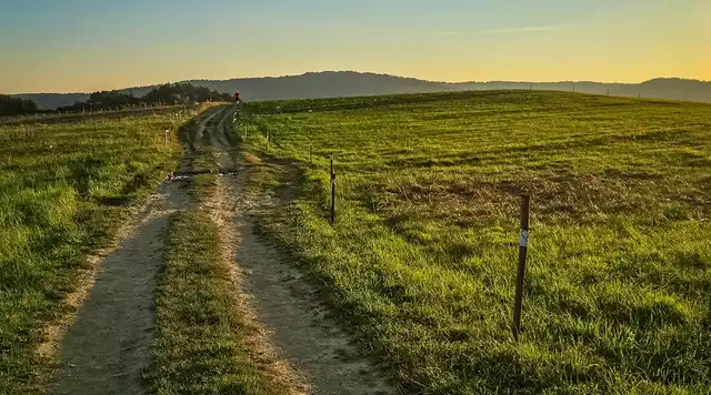
My trail stared in Adeje, next to the cemetery. The route went down the valley, through some plantations and farms. It was not marked as an official trail, just some roads, and paths. Later, a little up I’ve found some old markings, indicating that in the past it was indeed a hiking trail, but not anymore.

The ascent was long and exhausting. My path was sneaking up the hill, and there was no sight of the end while I had to cover almost 800 meters of the elevation.
An interesting thing is that when I’ve reached higher ground, the flora was getting more diverse and green. The reason for this are the clouds which were often present at higher altitudes, carrying extra moisture. I’ve noticed plants preciously keeping droplets of water on their leaves.

Montaña Carrasco
It took me about 2 hours to reach the close area of Montaña Carrasco, and this was when the fun began.
Suddenly everything was started looking completely different. It would be like I’d appear in another world. Steep rocky walls, deep ravines, a mist of clouds forming through the ridges. Everything created very moody atmosphere, and I was just stunned.

I’ve observed some birds of prey (probably buzzards or falcons), circling over the ravine. Their squeaks were repeated by the echo from the walls of the gorge. I stopped for a while and really enjoyed that moment.
My paths were traversing the side of the ravine, surprising me with stunning views every couple of minutes. At one point I’ve reached lonely, separated sharp rock formation which looked stunning. I wasn’t expecting to see anything like this. Again, I had to spend a good couple of minutes to enjoy it, look at the details and photograph it from different angles.

After a short break, I continued my run/hike (I don’t run uphills) and climbed to the top of the Montaña Carrasco. Not bad experience, but the top was entirely surrounded by the fog (or the clouds), so there was not much to see there. I enjoyed it quietly and then continued towards next part of the run.
Travers
It started with fantastic descent traversing a ridge. Was slightly downhill, but not too much, so I really enjoyed this part. Again the plants were very lush here, comparing to what you see down next to the town. At some point, the path flattened, and I was running through some pine forest making long traverse around the Barranco del Infierno, which was somewhere down.
I hiked this ravine when I was last time on Tenerife, and I quite enjoyed it. But I must say, going on the trail around it was very different, yet delightful experience.

The path was again twisting on the slopes but still leading me steadily downhill in the south-west direction. I stopped couple time to eat some gel and drink a Redbull as I’ve already started to feel fatigue.
I guess this fatigue was a reason I’ve almost injured my ankle. On the relatively easy path, I’ve falsely put my foot, and it hurt really badly. Throwing some swearing words I stopped. Fortunately, I had an elastic bandage in my backpack, and I used it to stabilize the ankle. Was still hurting and I was a bit afraid it could be a severe injury. But after few minutes of walking and limping, it got better, and I was able to continue my run.
A part of the trail which I really enjoyed running down. Not too steep, just right.

This missteps happened actually couple times later, luckily they were not so bad like a first one. But lesson learned. Need to carry always some medkit stuff and also practice running on bit more technical terrain. The same mistake in late 2016 caused an injury which took about 3 months of healing. I would rather not repeat that, ever!
Back to Adeje

The last descent, back to Adeje was actually almost as challenging as the descent. The path was very steep, full or rocks again twisting through the slopes of the valley. The surface was slippery in the first part because it rained slightly. I’ve tried to run but it was somewhat a vain effort, and I settled only for short moments of faster tempo when the surface was looking flat and safe.
In the end, I’ve finished the whole run in about 4,5h - quite tired as it was only my second day of running here and I was not yet adapted to such long distances. The whole route was 17km and 1258m of elevation gain. That’s quite an accomplishment!
Side note: All photos on this trail were taken with simple iPhone SE and processed in Lightroom.